This GPS Map Camera app merges camera functionality with GPS location tracking, enabling users to visually document their journeys. Key features include geotagging, GPS scanning, and GPS mapping, allowing for the creation of photo maps. The app's robust mapping system displays photos on a GPS map, showing their location relative to the user's route. Beyond its core camera function, it lets users add GPS location data to existing photos. Its intuitive design ensures seamless operation with GPS-enabled devices. Whether you're a professional photographer or a casual picture-taker, this app is ideal for adding geolocation information to your photos.
The GPS Map Camera App boasts six key benefits:
-
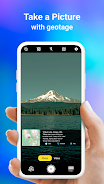
Integrated Camera and GPS: Capture photos and instantly geotagging them with precise location data, creating a visual travelogue.
-
Versatile Photo Capture and Tracking: Use the built-in GPS camera or add GPS location data to existing images using the app's geotagging feature.
-
Comprehensive Mapping: Easily view photos on an integrated GPS map, visualizing their location along your route.
-
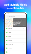
Customizable Date/Time Stamps: Select and add date and time stamps to your photos for precise record-keeping.
-
Personalized Photo Management: Save photos with custom names and utilize live navigation for efficient organization.
-
Lightweight Alternative: A Lite version offers many core features while minimizing device storage usage.
Tags : Photography